Friday, December 7, 2012

Geodesign at Asia Pacific User Conference

From  November 5-7  Esri Asia Pacific User Conference (APUC) took place in Auckland at Sky City Convention Centre. The Conference was hosted by the company I work for, Eagle Technology Group Ltd. We had the privilege of having a number of people from Esri at the conference including Jack Dangermond, Bernie Szukalski, Mary Jo Fraley, Dave Wrazien, Derek Law, Nathan Benett, Michael Boryski, Dean Angelides, Leonard Jayamohan, Michael Kim, Dave Buyers, Linda Peters and Sandy Szukalski.


Plenary session

I had the privilege and honor of presenting at several sessions. Most of these presentations were about CityEngine and geodesign. The first task was to prepare a 10 minute demonstration of CityEngine in geodesign for plenary session on first day of the Conference. If you are familiar with CityEngine and it's features you know it is a difficult choice on its own. Plus, I had to demonstrate the other parts of ArcGIS and their relevance for geodesign. For this very short demonstration I have decided to demonstrate the following workflow:
  • Create a new subdivision in CityEngine
  • Export designed options to file geodatabase
  • Run analysis on new subdivision in ArcScene
  • Export layers from CityEngine to WebScene
If you would like to see the video of the presentation follow this link and skip to 2:19:41 for start of demo.

Here are some screenshots form the CityEngine project made for plenary session.


High density residential with grid pattern

Low density residential with radial roads

Screenshots above show two alternative designs for this subdivision. First one is a high(er) density residential with grid road pattern. To make alternative design a bit more interesting we went with radial roads and low(er) density residential option with inclusion of open/green space and trees planted on some parcels.

One of features in CityEngine 2012 is ability to visualize buildable volumes. These volumes are defined differently for different district plan zones. Screenshots below show buildable volumes for different zones in different colours.
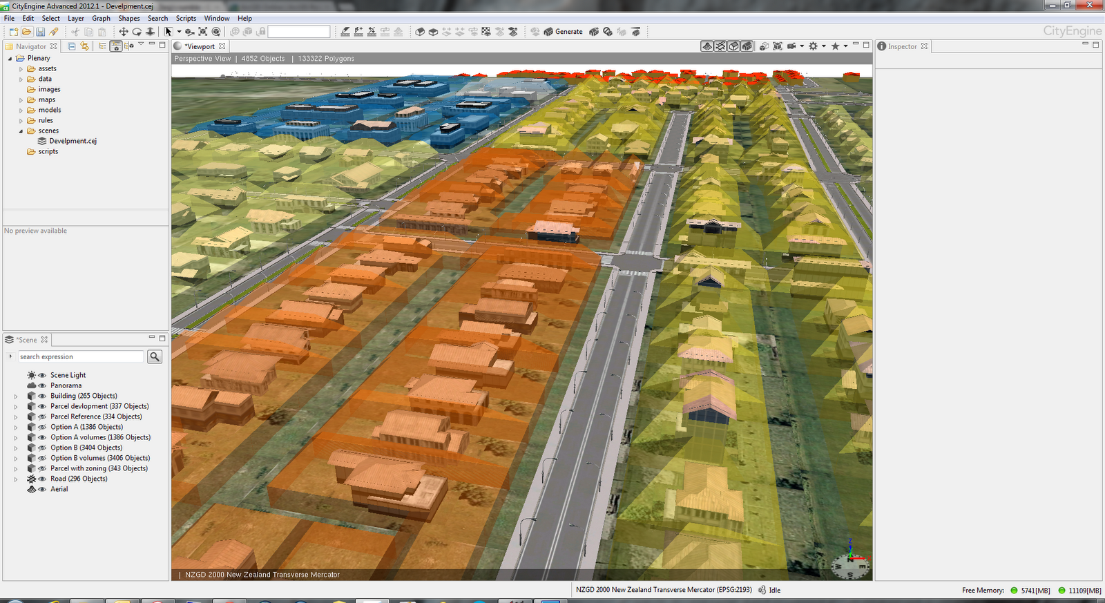
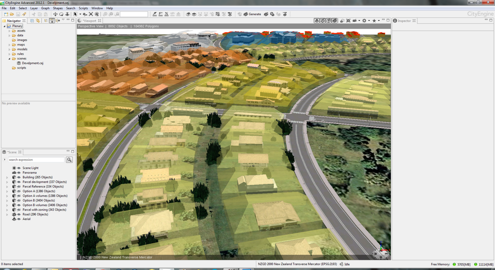
Buildable volumes by zoning type

Different zones volumes

Here are few more screenshots from the project.


Generated design options were exported to file geodatabase and used in ArcScene for analysis. Here is how data looks in ArcScene.


Lastly, the selected layers from scene in CityEngine are exported as WebScene. If you would like to have a look it is available on ArcGIS.com. You will have to use WebGL capable browser like Chrome or FireFox.

Geodesign workshop

My second engagement was conducting a half day workshop titled "Geodesign – Using ArcGIS to Improve the Design Process". In the first part of this workshop we briefly discussed the principles of geodesign. To get everyone engaged I devised an activity where each team of four carefully picked attendees had to produce first draft design of subdivision  in Auckland. Design teams had a mixture of representatives from organizations like local government, consultants, utilities, conservation. They used very simple tools - coloured pencils and printed black & white map. The key here was collaboration like in every geodesign project. The second part of the workshop was all about CityEngine. We discussed basics of CityEngine and explored some possibilities for rule development in this example of subdivision.

Third task was a breakout session on "Using CityEngine 2012 for Geodesign" on Tuesday. In this session I gave a brief overview of CityEngine and discussed with the audience some options and approaches taken  in example shown in screenshots above. Slides from the presentation will be available on NZ Esri Users Group web site.

All work I did for the conference would not be possible without support of several people. On of them is my colleague Bernice O'Hanlon who designed "Option A" and "Option B". Another big Thank You goes to esri Zurich staff Gert Van Maren and Matthias Buehler.

NZ textures update

In my previous post I mentioned that some information about plain image texture sizes for CityEngine users would be beneficial. It didn't take long for Monier to provide this information.

Proper texture sizes are in updated version of PDF. I you don't want to get the whole document here is the relevant table.


Here is a very simple example of one of these textures in CityEngine.


Friday, November 23, 2012

Monday, November 12, 2012

New Zealand textures for CityEngine

Working with 3D models is great fun but when it comes to finding good textures it may not be so fun anymore. I am working with CityEngine since mid last year and I am always on lookout for good textures. If they are free then it's even better. Searching on the web for texture packs and/or generic textures for buildings (mainly roofs and facades) wasn't very successful.

Luckily, in October I got in touch with Monier, one of the biggest brick and tile manufacturers in New Zealand. They were planning on releasing a texture pack suitable for use in 3D Max, AutoCAD, Revit, SketchUp, CityEngine and other applications that use plain image textures. Unfortunately, the texture pack was not ready in time for Esri Asia Pacific User Conference (APUC). I wanted to use the Material Library for rendering of buildings in CityEngine at APUC. On the very last day of the Conference I got an e-mail announcing the release of Material Library.

Material Library is now available as free download. From Material Library page choose your preferred format or if you prefer plain images go to the Individual Bricks page for wall cladding (bricks). If you are after roof tiles range select Tile Range or Individual Tiles.

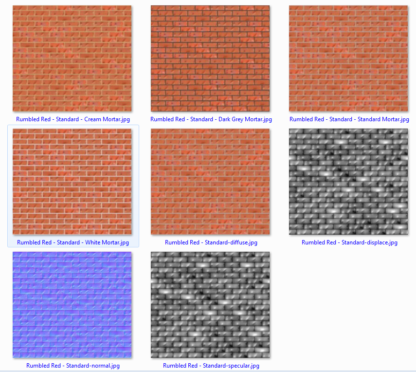
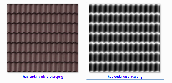
Being a large brick and tile maker Monier has a large range of products and that gives us, 3D users, a very nice collection of textures. Also they have included bump/normal/displacement maps for both bricks and tiles. Here are  few examples.


Closer look at the bricks example screenshot shows different colours of mortar available, normal map and specular map too. A nice bonus!

For use in CityEngine I have copied all brick textures in a single folder and then just using fileRandom like below to select textures and then texture set of buildings in New Zealand set of textures.

attr wall_tex = fileRandom("assets/CEmonierbricks/*Mortar.jpg")
attr wall_normal = substring(wall_tex,0,find(wall_tex,"-",1))+"-normal.jpg" 
attr wall_spec = substring(wall_tex,0,find(wall_tex,"-",1))+"-specular.jpg"


Here is a quick example of few buildings using these textures in CityEngine 2012.


These images are from early version of the rule since I am not certain of correct sizing of textures. That information (proper size of texture in metres, e.g. single tile covers 2.2m x 2.2m)  is missing from texture pack currently. Hopefully, this will be included in next/updated release of Material Library.

Great job Monier!

Now that we have a good example from Monier it would be great if other manufactures (other types of cladding, doors, etc) would follow the suite. Anyone?


Monday, October 1, 2012

CityEngine 2012 - First look

CityEngine 2012 is imminent and there are several new features worthy of your attention. Some of them will be of interest to GIS professionals only but there is plenty of new functionality for everybody.

Here are key new features:

  • 3D Editing of generated models
  • Full support for file geodatabase
  • Web Scenes sharing via ArcGIS Online
  • New CGA functionality
  • New examples
  • Licensing mechanism update
Here are some details about above points.

3D Editing of generated models
Until now it was not possible to edit models generated by rules. Now there is a set of basic 3D editing tools and functions that allows SketchUp like editing. Edited multipatches can be saved back to the file geodatabase. To get most out of it check out the Tutorial 14 Basic Polygonal Modeling.


Full support for file geodatabase
The big improvement is import and export of textured multipatches. Not only that textures are supported but one can choose to append to existing feature class, update it or create a new one. This will make it much easier to create several design options for planners and designers.


Web Scenes sharing via ArcGIS Online
Scenes created in CE can now be shared with much greater audience. The scene is uploaded to ArcGIS Online and there you specify how it will be shared. Some examples are already live on ArcGIS.com 3D Web Scenes page. This is an excellent opportunity for planners, urban designers, landscape architects to present solution to wide (or limited) audience. Just to remind you that your browser must support WebGL. Latest versions of Chrome and FireFox work just fine. Below is an example of tiny web scene exported from CityEngine before it is published to ArcGIS Online.


New CGA functionality
New envelope operation is set to be an instant hit with urban designers and planners. It allows you to visualize build volumes. When used in tandem with mass models or as-built representation one can quickly find out problem areas. Envelope operation is also nicely demonstrated in this short video.


For more accurate analysis go to ArcGIS and use Intersect 3D tool.

Before publishing your scene as Web scene you will most likely use reduceGeometry operation to reduce number of vertices. For troublesome geometry use cleanupGeometry operation.

For full list of changes check the CGA Changelog in CityEngine help.

There are also changes in user interface. Icons on toolbars are now in single colour - black. 


###

And now something little bit different. I have a privilege to present a half day workshop on Geodesign at Asia Pacific User Conference in November in Auckland. Several papers about use of CityEngine will be  also presented. Hope to see you there.


Friday, August 24, 2012

GeoCart 2012

Starting from next Monday, 27th August following ten days will be a peak of activity for cartography in New Zealand. In just ten days three events will take place - Map Design with ArcGIS Workshop, GeoCart conference and Mountain Cartography Workshop. 

First event is Map Design workshop where Dr Kenneth Field and Dr Aileen Buckley will show attendees number of cartographic techniques in ArcGIS and how to create maps for web. This workshop continues the series from last one led by Cynthia Brewer. Workshop will be an excellent opportunity to learn and discuss cartographic tips and tricks from esri's top echelon of cartography.

This will be my fourth GeoCart conference and I am really looking forward to be there. Each conference offers great number of paper presentations, great map display and competition and most importantly opportunity for networking. As usual there will be a number of great speakers including Aileen Buckley, David Fairbairn, Tom Patterson, Roger Smith and Georg Gartner, President of the ICA.

If you want to combine cartography and potential to view volcanic eruption first hand then take a trip into "danger zone" at Mount Tongariro where 8th Mountain Cartography Workshop will take place. 

I'll try to keep posting (and maybe tweet) about these events over next couple of weeks. In worst case scenario I'll post an overview when all is done.

Hope to see you there.

Asia Pacific User Conference 2012

Every year in November members of Esri's user community in New Zealand gather at New Zealand Esri User Conference. This year is different. This time it is not just a New Zealand conference but the conference for Asia Pacific region. For this conference we are expecting about 500 visitors from whole region and that gives us new networking opportunities. 

The Conference will be held from 5-7 November in Auckland at the Sky City Convention Centre.
Esri's founder Jack Dangermond will be here as well as other speakers from esri.

With increased number of participants there is an increase in the number of paper submissions. There is just under a 100 papers submitted and review and selection process is now under way.

With increased coverage area there are more vendors showcasing their products and solutions. The list includes IBM, Telvent, Schneider Electric, TomTom, Terralink, GBS and others.

Before the Conference there will be a number of workshops (half day and full day) covering topics from LiDAR and 3D to GeoDesign and Project Management.

To find out more about the Conference check the Esri Asia Pacific User Conference page.

NZ User Conference is know for a good atmosphere and most of the conference dinners had a theme. The theme for this conference is "A day at the races" since it will be in the time of Melbourne Cup. Feel free to take your own spin on the subject and get that fancy outfit.

Take a look at some photos from past conference dinners and see you there!