Showing posts with label ArcGIS. Show all posts

Wednesday, April 8, 2015

What's new in CityEngine 2015

New version of CityEngine is out. Elliot Hartley already mentioned it in his blog post but there are some other changes. One prominent change is Scene tab. Here is the default appearance (for Redlands Redevelopment project.


From this it may not be clear what is the left square used for. It is used to assign a colour to that layer. Simple click on the box brings up a colour selector and result is like below.


Another new feature of Scene tab is ability to create layer groups . In Scene tab right mouse click and from context menu select New, Group Layer


New group is empty and one can just simply drag & drop layers into the group, just like in ArcMap. Of course, new group layer can have a colour assigned. If it is assigned it overrides colours of layers within it.


From CGA standpoint getTreeKey is important. From help documentaion:

The unique TreeKey of the shape being derived, formatted as a string list. The TreeKey is a list of integer numbers denoting the path from the root shape to the shape being derived in the shape tree. Each number denotes the 0-based child index

Sample code for using getTreeKey

CGA Code
Init-->
    print(getTreeKey() + " - Init") 
 center(xz)
 extrude(10)
 comp(f) { front: Facade}
 
Facade-->
 print(getTreeKey() + " - Facade")
 split(y) {'0.5 : Floor }*
 
Floor-->
 print(getTreeKey() + " - Floor")
 split(x) { '0.1 : Wall | '0.3 : Window | '0.1 : Wall }*
  
Wall-->
 print(getTreeKey() + " - Wall")

Window-->
 print(getTreeKey() + " - Window")


and it's output

0; - Init
0;0; - Facade
0;0;0; - Floor
0;0;1; - Floor
0;0;0;0; - Wall
0;0;0;1; - Window
0;0;0;2; - Wall
0;0;0;3; - Wall
0;0;0;4; - Window
0;0;0;5; - Wall
0;0;1;0; - Wall
0;0;1;1; - Window
0;0;1;2; - Wall
0;0;1;3; - Wall
0;0;1;4; - Window
0;0;1;5; - Wall

More on new features when I spend little bit more time with this version.

Thursday, December 12, 2013

New in CityEngine 2013 - Part 4

Street improvements

In the last post I describe the situation when I import land parcel and road centrelines and the problem there is that parcels don't have defined street edge/frontage. In 2012 one can select the required edge of a parcel and set it as First/Street edge. To do that for whole lot you had to reach to Python. With Python script there were cases requiring multiple runs but it was doable. With CE 2013 new option is available - 'Compute First/Street Edges'.


Running this on example parcels and roads from previous post red shows the street edges.


This is great improvement and I'll use this on regular basis.

Another new feature is ability to create more realistic motorway/freeway connections/intersections. Here is an example of default smart type of intersection.


After selecting the node I can change it to 'Freeway' to achieve this:


This of course changes the shape of road segment and the changes are as below.


The last option I'll test today is changing the curves from straight to curves. There are no changes here so example pictures will suffice.


New in CityEngine 2013 - Part 3

Now I am re-creating a project in CE2013 I did very recently in the previous version. Following the same steps and using default settings of CE2013 I noticed some differences in generated blocks and models. The demo I was working on is using Desert City example rules and assets and here is the screenshot from version 2012.


When doing the same workflow in 2013 here is what I got


In CE2013 blocks have rounded corners and the models for buildings have less variation. Comparing street creation setting from both versions in 2013 street width is now 7 (changed from 14) and lane width setting is not there. So far I can't confirm if rounding of the created blocks is a result of change in import module for OSM. I'll do more testing and post the results soon.

Majority of local councils in New Zealand use CRS (Core Record System) as source of parcel and road centreline data. Importing these in CE (after some cleanup of parcels) would produce situation like below.


In this release we can use 'Fit Widths to Shape' option from Graph menu. To test this I have intentionally picked an area where we have simple, straight streets and some more interesting ones. The result is shown below.

Some work is required and it could be as simple as tuning the parameters used. I will definitely explore this option whole lot more.

While talking about street shapes, there are new standard shapes (and rules) available

  • Freeway
  • FreewayEntry
  • RoundaboutIsland
  • Roundabout
  • RoundAboutEntry
  • Joint


This opens up options for greater tuning and control of street shapes. I like the options for roundabouts since there are lot of them in New Zealand.

Next option to explore is bridge generation but for that I'll have put aside little bit more time...

Wednesday, December 11, 2013

New in CityEngine 2013 - Part 2

Now all tutorial and examples are downloaded and it is time to check Change log. Elliot Hartley already had a post showing these here but I'll check if there are any changes since then.

There are no changes, so that list is still valid.

From that list here are the ones I'll have closer look:


  • envelope operation due to great power and applications in planning
  • cleanupGeometry, comp, extrude, split operations for supporting holes. This may produce interesting models. geometry.nFaces, geometry.area,geometry.volume functions support holes (there is a risk of losing them in subsequent operations)

Important changes:


attr/const functions evaluation order - "Starting with 2013.1, all attr/const functions are evaluated before the start rule is applied, on the initial shape with a seedian derived from the initial shape's seedian. The initial shape's random number generator state is not affected. While the new approach makes CGA coding more "intuitive", it changes the behaviour compared to older versions.". This will require change of habits and bit more structure when writing rules

inf/nan checks: "CGA 2013.1 introduces a unified inf/nan behaviour: checking of all float paramers of builtin functionality can be set to either "ignore" (= don't check), "abort with error" or "replace with zero" see Grammarcore Preferences). The default behaviour is "replace with zero", which comes closest to the classic behaviour." While CGA 2013.1 provides more debugging capabilities regarding inf/nan values, the behaviour is different than in previous versions.


Envelope operation

New parameter direction is added with two options - normal or world.up. Changing existing rules won't be difficult and all you need to do is change from 

envelope(MaxHeight, FrontBaseHeight, FrontAngle, BackBaseHeight, BackAngle, SideBaseHeight, RightAngle, SideBaseHeight, LeftAngle)

to 

envelope(world.y, MaxHeight, FrontBaseHeight, FrontAngle, BackBaseHeight, BackAngle, SideBaseHeight, RightAngle, SideBaseHeight, LeftAngle)

for the rule I had in my example. So if you are importing your existing 2012 projects minor changes will be required but you may want to consider using new features and functions and keep in mind important changes listed above.

While this is useful addition there is room for improvement or handling of special cases. Several city councils in New Zealand have a requirement for building envelopes determined by a combination of street and compass orientation. I should put this on ides site and see how many votes it will get.

Now it's time to review and rewrite previous work.

New in CityEngine 2013 - Part 1

After a long wait CityEngine 2013.1 is finally released. At the moment it is available for distributors only but general release will follow in few days.

Here I'll describe new features as I encounter them while working with CE 2013. This is by no means ranking or other "top X features" list.

Here we go!

Installation

If you already have CE 2012 you can install CE 2013 in different folder (default location is fine) and having single use I didn't have to do anything license wise. Furthermore, now I can run both versions on my machine! Not in the same time of course. As usual, we have examples and tutorials available for download. These are updated for new version but I don't expect any dramatic changes.

CityWizard


New City Wizard looks very much like the old one. It is still using same heightfield, texture and obstacle map.


New are the structure of the assets folders and large number of textures (400+).  Also we now have 80 new trees created by e-on software in 3 different forms. These are handled by a separate rule in the wizard.

Fan tree

Model tree

Analytical tree


There is a new addition to user interface - a progress bar when generating models.


Of course, new rules are driving the City Wizard but I didn't have time yet to explore and learn from this example.

That's it for now, more to come.


Friday, December 7, 2012

Geodesign at Asia Pacific User Conference

From  November 5-7  Esri Asia Pacific User Conference (APUC) took place in Auckland at Sky City Convention Centre. The Conference was hosted by the company I work for, Eagle Technology Group Ltd. We had the privilege of having a number of people from Esri at the conference including Jack Dangermond, Bernie Szukalski, Mary Jo Fraley, Dave Wrazien, Derek Law, Nathan Benett, Michael Boryski, Dean Angelides, Leonard Jayamohan, Michael Kim, Dave Buyers, Linda Peters and Sandy Szukalski.


Plenary session

I had the privilege and honor of presenting at several sessions. Most of these presentations were about CityEngine and geodesign. The first task was to prepare a 10 minute demonstration of CityEngine in geodesign for plenary session on first day of the Conference. If you are familiar with CityEngine and it's features you know it is a difficult choice on its own. Plus, I had to demonstrate the other parts of ArcGIS and their relevance for geodesign. For this very short demonstration I have decided to demonstrate the following workflow:
  • Create a new subdivision in CityEngine
  • Export designed options to file geodatabase
  • Run analysis on new subdivision in ArcScene
  • Export layers from CityEngine to WebScene
If you would like to see the video of the presentation follow this link and skip to 2:19:41 for start of demo.

Here are some screenshots form the CityEngine project made for plenary session.


High density residential with grid pattern

Low density residential with radial roads

Screenshots above show two alternative designs for this subdivision. First one is a high(er) density residential with grid road pattern. To make alternative design a bit more interesting we went with radial roads and low(er) density residential option with inclusion of open/green space and trees planted on some parcels.

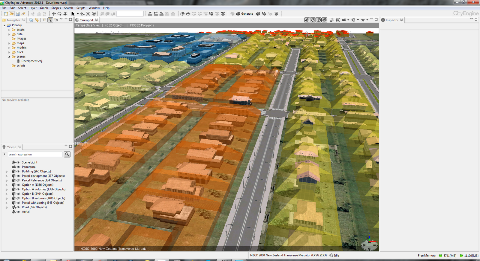
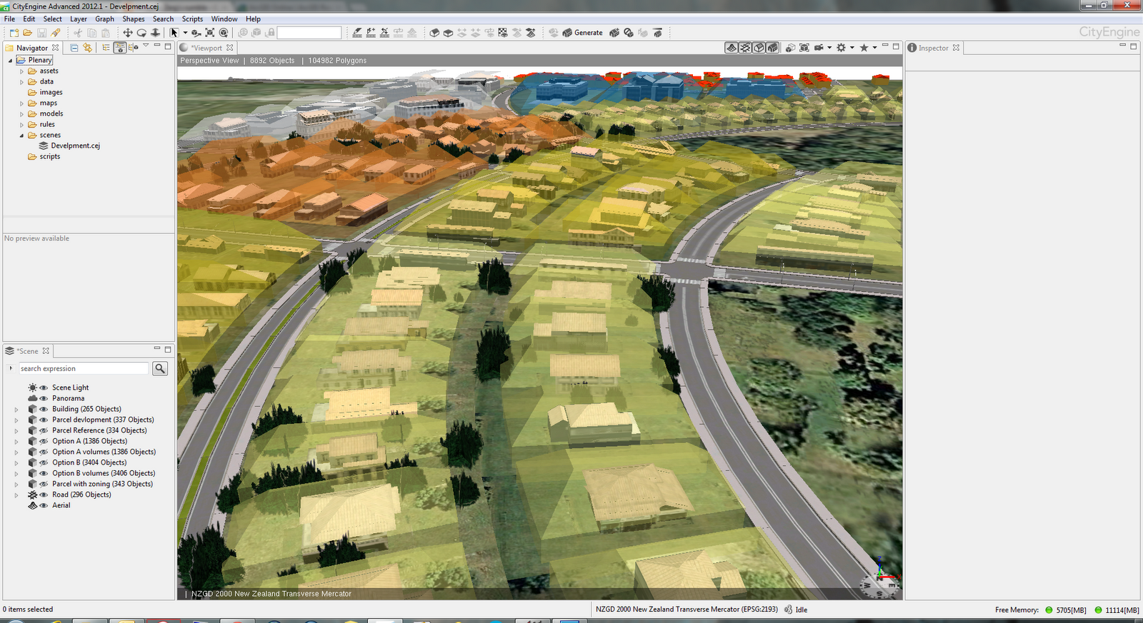
One of features in CityEngine 2012 is ability to visualize buildable volumes. These volumes are defined differently for different district plan zones. Screenshots below show buildable volumes for different zones in different colours.

Buildable volumes by zoning type

Different zones volumes

Here are few more screenshots from the project.


Generated design options were exported to file geodatabase and used in ArcScene for analysis. Here is how data looks in ArcScene.


Lastly, the selected layers from scene in CityEngine are exported as WebScene. If you would like to have a look it is available on ArcGIS.com. You will have to use WebGL capable browser like Chrome or FireFox.

Geodesign workshop

My second engagement was conducting a half day workshop titled "Geodesign – Using ArcGIS to Improve the Design Process". In the first part of this workshop we briefly discussed the principles of geodesign. To get everyone engaged I devised an activity where each team of four carefully picked attendees had to produce first draft design of subdivision  in Auckland. Design teams had a mixture of representatives from organizations like local government, consultants, utilities, conservation. They used very simple tools - coloured pencils and printed black & white map. The key here was collaboration like in every geodesign project. The second part of the workshop was all about CityEngine. We discussed basics of CityEngine and explored some possibilities for rule development in this example of subdivision.

Third task was a breakout session on "Using CityEngine 2012 for Geodesign" on Tuesday. In this session I gave a brief overview of CityEngine and discussed with the audience some options and approaches taken  in example shown in screenshots above. Slides from the presentation will be available on NZ Esri Users Group web site.

All work I did for the conference would not be possible without support of several people. On of them is my colleague Bernice O'Hanlon who designed "Option A" and "Option B". Another big Thank You goes to esri Zurich staff Gert Van Maren and Matthias Buehler.

Monday, November 12, 2012

New Zealand textures for CityEngine

Working with 3D models is great fun but when it comes to finding good textures it may not be so fun anymore. I am working with CityEngine since mid last year and I am always on lookout for good textures. If they are free then it's even better. Searching on the web for texture packs and/or generic textures for buildings (mainly roofs and facades) wasn't very successful.

Luckily, in October I got in touch with Monier, one of the biggest brick and tile manufacturers in New Zealand. They were planning on releasing a texture pack suitable for use in 3D Max, AutoCAD, Revit, SketchUp, CityEngine and other applications that use plain image textures. Unfortunately, the texture pack was not ready in time for Esri Asia Pacific User Conference (APUC). I wanted to use the Material Library for rendering of buildings in CityEngine at APUC. On the very last day of the Conference I got an e-mail announcing the release of Material Library.

Material Library is now available as free download. From Material Library page choose your preferred format or if you prefer plain images go to the Individual Bricks page for wall cladding (bricks). If you are after roof tiles range select Tile Range or Individual Tiles.

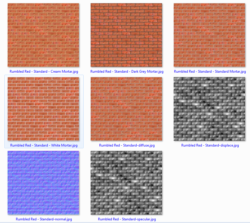
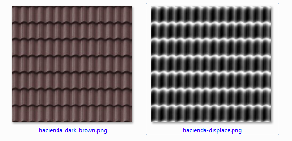
Being a large brick and tile maker Monier has a large range of products and that gives us, 3D users, a very nice collection of textures. Also they have included bump/normal/displacement maps for both bricks and tiles. Here are  few examples.


Closer look at the bricks example screenshot shows different colours of mortar available, normal map and specular map too. A nice bonus!

For use in CityEngine I have copied all brick textures in a single folder and then just using fileRandom like below to select textures and then texture set of buildings in New Zealand set of textures.

attr wall_tex = fileRandom("assets/CEmonierbricks/*Mortar.jpg")
attr wall_normal = substring(wall_tex,0,find(wall_tex,"-",1))+"-normal.jpg" 
attr wall_spec = substring(wall_tex,0,find(wall_tex,"-",1))+"-specular.jpg"


Here is a quick example of few buildings using these textures in CityEngine 2012.


These images are from early version of the rule since I am not certain of correct sizing of textures. That information (proper size of texture in metres, e.g. single tile covers 2.2m x 2.2m)  is missing from texture pack currently. Hopefully, this will be included in next/updated release of Material Library.

Great job Monier!

Now that we have a good example from Monier it would be great if other manufactures (other types of cladding, doors, etc) would follow the suite. Anyone?


Monday, October 1, 2012

CityEngine 2012 - First look

CityEngine 2012 is imminent and there are several new features worthy of your attention. Some of them will be of interest to GIS professionals only but there is plenty of new functionality for everybody.

Here are key new features:

  • 3D Editing of generated models
  • Full support for file geodatabase
  • Web Scenes sharing via ArcGIS Online
  • New CGA functionality
  • New examples
  • Licensing mechanism update
Here are some details about above points.

3D Editing of generated models
Until now it was not possible to edit models generated by rules. Now there is a set of basic 3D editing tools and functions that allows SketchUp like editing. Edited multipatches can be saved back to the file geodatabase. To get most out of it check out the Tutorial 14 Basic Polygonal Modeling.


Full support for file geodatabase
The big improvement is import and export of textured multipatches. Not only that textures are supported but one can choose to append to existing feature class, update it or create a new one. This will make it much easier to create several design options for planners and designers.


Web Scenes sharing via ArcGIS Online
Scenes created in CE can now be shared with much greater audience. The scene is uploaded to ArcGIS Online and there you specify how it will be shared. Some examples are already live on ArcGIS.com 3D Web Scenes page. This is an excellent opportunity for planners, urban designers, landscape architects to present solution to wide (or limited) audience. Just to remind you that your browser must support WebGL. Latest versions of Chrome and FireFox work just fine. Below is an example of tiny web scene exported from CityEngine before it is published to ArcGIS Online.


New CGA functionality
New envelope operation is set to be an instant hit with urban designers and planners. It allows you to visualize build volumes. When used in tandem with mass models or as-built representation one can quickly find out problem areas. Envelope operation is also nicely demonstrated in this short video.


For more accurate analysis go to ArcGIS and use Intersect 3D tool.

Before publishing your scene as Web scene you will most likely use reduceGeometry operation to reduce number of vertices. For troublesome geometry use cleanupGeometry operation.

For full list of changes check the CGA Changelog in CityEngine help.

There are also changes in user interface. Icons on toolbars are now in single colour - black. 


###

And now something little bit different. I have a privilege to present a half day workshop on Geodesign at Asia Pacific User Conference in November in Auckland. Several papers about use of CityEngine will be  also presented. Hope to see you there.


Thursday, October 27, 2011

Esri CityEngine released


Back in July at Esri User Conference in San Diego big news was acquisition of Procedural and it’s product CityEngine. Yesterday at European User Conference in Madrid new version od CityEngine is announced and released. New version is called Esri CityEngine and it shows first steps of integration and support for esri data types.
In addition old link to www.procedural.com now redirects to new home for CityEngine under esri corporate site http://www.esri.com/software/cityengine/index.html fitting nicely in rest of the web site. There are small changes in order of features like GIS/CAD data support is listed as first feature.

CityEngineWeb

When I get an opportunity to spend more time with CE I’ll describe new features in details. Some of key features include:
  • Import of File GDB and shapefile
  • Import of KML/KMZ
  • Import of TIFFs for heightmaps
  • Projections (including New Zealand Transverse Mercator)
  • Changed/updates help system available on-line
As before free trial is available and CE is available for Windows (both 32 and 64bit), Linux and Mac. It is a small download (as you may expect) and I think it is worth trying it out.

CEdownload

Until next time have fun creating whole new cities!

Wednesday, July 13, 2011

Esri acquires Procedural

One of most interesting news I have heard from esri in a while came yesterday morning. My friend Ryan is attending Esri International User Conference and he sent me a brief e-mail:

Esri bought procedural and city engine. Just found out.

The reason why I find this exciting is in the potential of what we, GIS specialist, can do with tool like CityEngine. If you don’t know about Procedural and their product you may have seen a documentary titled Megacities from National Geographic. This was done in CityEngine and other tools for media production. To find out more read this article. If you liked Prince of Persia movie, the city was built in CityEngine. For gamers out there, Unreal, CryEngine, Unity engines are integrating with CityEngine too.

What does CityEngine do?

From Procedural’s web site:

CityEngine is a standalone software that provides professional users in entertainment, architecture, urban planning, GIS and general 3D content production with a unique conceptual design and modeling solution for the efficient creation of 3D cities and buildings.

It is standalone tool that can rapidly create large number of objects. Objects can be buildings, wall, roads, street furniture or they can be imported. Object generation and placement is based on rules. Rules can be easily created and modified and scene is easily regenerated.

CityEngineRules

Above screenshot is taken from a tutorial video. Visit Support page for access to lot more videos. For automation scripting language is the Python. Another bonus!
CityEngine and GIS

Benefits and use cases for using CityEngine in or with GIS are numerous. Firstly, it supports shapefile as input data format. Since it is now part of esri family I would expect geodatabase support in near future. Having shapefiles allows you to control or define rules from those attribute values, like number of floors, building type (residential, commercial, etc), building style/era and so on. Example can be found over here with more information and brief video is below.

ArcGIS and CityEngine

Some areas where CityEngine could be used in GIS:

  • City planning
  • Road (re)design
  • Landscape design and evaluation
  • Shadow analysis
  • Viewshed analysis
  • Intelligence and security analysis
  • Telecommunications

Map-controlled modeling feature is the one that almost every GIS user can take advantage of. An image determines type of features that will be generated or where blocking zones will be.

Map controlled modeling

Parametric modeling allows dynamic changes of features. Take streets for an example. This is very nicely illustrated in this video.

Interactive streets remodeling

There is lot more to be explored and tested but that is for another time.

Closing thoughts

Procedural and CityEngine are great addition to the set of tools esri users have at their disposal and I am really looking forward to work with it again. In addition to being great tool, support is also very good. Turn around time on the question I asked was few days (head office is in Switzerland) and answers were simple and precises. They did follow up afterwards and provided me with number of useful links.

Procedural is frequently updating the software and below are some features important to esri users.

  • Export to shapefile
  • Export to Collada
  • Mulitpatch support

Now it is waiting game to see what and how CityEngine will be offered to esri customers.

Tuesday, September 14, 2010

LIDAR Analyst 5.0 released

It has been a while since I have used LIDAR Analyst in ArcGIS. In very early days it had interesting features like building extractions, tree/forest extraction but it worked on images only. But that was long time ago. This release comes from Overwatch Systems.

Latest version reads typical inputs like LAS, ASCII, 3D shapefile and DEM and this is to be expected. Main features include:


  • Importing and processing LIDAR data returns in a variety of data formats including LAS, ASCII text, DEM, MrSID Compressed LAS, or point shape file
  • 100% automated 3D feature extraction
  • Simple, fast and accurate extraction of bare earth terrain
  • Extraction of 3D buildings with complex rooftops
  • Extraction of tree points and forest regions
  • Extraction of contour lines for depicting elevation
  • Terrain Analysis
  • Automated attribution for extracted features such as building height, orientation, roof type, stem diameter, crown width, etc.
  • Conversion tools for ASCII text and point shape file to LAS format
  • Exporting result features to KML file format to display in Google Earth™ and Microsoft Virtual Earth
  • Classification of LAS point clouds based on LIDAR Analyst extractions and user settings
  • Batch processing
  • Advanced 3D editing tools for manipulating vectors and terrain surfaces
  • Integration with ESRI’s Model Builder
Features I would be interested in testing would be automated feature extraction because I have seen cases where instead of squared buildings you end up with wacky shapes. This was the case in particular where point distance was larger (over 1.5 m). 

KML export could be an interesting one. Different clients handle different versions of KML differently. ArcGIS Explorer ignores unsupported tags (namely from 2.1 version of KML) but should use and render other tags.

As an Esri user I am interested in geoprocessing and Model Builder integration.  At this time there isn't much on this topic apart the quote in brochure:
Integration with ESRI's Model Builder provides true end-to-end geoprocessing capabilities.
Brochure for LIDAR Analyst is available here.

If you get an opportunity to test it or some of it's features I would like to hear from you.

Saturday, July 10, 2010

ArcGIS 9.3.1 SP 2 released

While part of Esri team was busy developing ArcGIS 10 another part was busy working on issues in 9.3.1 version. Service pack 2 is fixing a number of issues. Exact counts are below.

  • Desktop - 84
  • Engine - 2
  • Server (general) - 6
  • REST - 5
  • Web ADF - 3
  • Java - 2
Here are my picks of important fixes for Desktop.

ArcGIS Desktop

  • NIM014000 - Converting EMF picture marker symbols to representations may result in unexpected jaggedness of outlines and missing interior fill elements.
  • NIM031270 - Selecting cartographic representation with the cartographic representation select tool is significantly slower than selecting with the editor tool and the selection tool.
  • NIM036834 - If you have an exception that has a dirty area crossing it and validate the topology the exception becomes an error.
  • NIM037043 - When a feature is selected, and a reference scale is used, the selected point feature ignores the reference scale.
  • NIM039914 - If a data frame contains one or more polygon layers symbolized with bar graphs, no attributes are included in the PDF export, even with the export option 'Export PDF Layers and Feature Attributes' selected.
  • NIM041239 - Stopping the trace tool at the beginning of a true curve adds a circle to the sketch.
  • NIM042869 - Using Near tool with default search tolerance gets incorrect results, as not all input features can find the distance to the near feature.
  • NIM043178 - ArcMap crashes when reconciling and memory increases to almost 2GB (virtual bytes).
  • NIM047109 - Spatial join in SDE geodatabase does not return any rows.
  • NIM048174 - Reconciling an edited attributed relationship table, in favor of edit version, fails with error message when related feature has been deleted in the target version.
  • NIM050124 - Intersecting Layers Mask GP tool fails to produce proper masking polygons in 9.3.1.
  • NIM051339 - Conversion of character markers into representation markers results in the TOC display of the marker at 75-80% of expected size.
  • NIM052264 - Feature Outline Masks tool crashes when running against lines or polygons symbolized without representations.
  • NIM052349 - Joined attributes are no longer visible in the Identify window if one of the layers is using Representations.
  • NIM052365 - Relationship classes created between double data types in a File Geodatabase return inconsistent results when performing queries.
  • NIM053271 - ArcGIS Globe Memory Leakage when adding graphics. Memory never releases.
  • NIM054377 - Hash line symbols have inconsistent spacing compared to cartographic line symbols.
  • NIM054416 - Features in conflict do not draw in the Conflict Detection window if layer is drawn with representations and you are not the data owner.
  • NIM055237 - Calculate Locations geoprocessing tool does not honor the parameter values for the location fields when run from a python script.
  • NIM056157 - After exporting the shapefile to a personal geodatabase feature class, the value for the geometry's grid is not correctly calculated; this results in the features disappearing in random map scales.
  • NIM056289 - Reconcile fails with the error, "Feature is deleted. The operation was attempted on an empty geometry."
  • NIM056710 - Memory leak in the in-memory feature class.


ArcGIS Server general fixes

  • NIM036787 - WMS enabled map service is a little shifted (a pixel or two) against the original data when both are added into ArcMap. The shift is not present if WMS capability is not enabled for the map service. - Informix Direct Connect does not work for Linux ArcGIS Server.
  • NIM049389 - ArcGIS Server WMS Service layer in ArcMap does not render at the scale range set in the .mxd.
  • NIM050650 - Python Object ARCSDESQLEXECUTE returns encoded output when used on Solaris with ArcGIS Server.
  • NIM051258 - Java applications connecting to ArcGIS Server through local connections (DCOM) are disconnected from the server after a 10-minute time out period.
  • NIM052700 - Korean fonts do not allow ArcGIS Server Services .Net to start on Windows 2003 Korean edition.
  • NIM056870 - 9.3 Image service WMS doesn't support XML format for exceptions and will return an error if accessed using ArcGIS 10 as client.


REST API fixes

  • NIM042583 - REST Query Layer and KML Server requests do not return valid KML if the layers in the map document used to create the service have a geometry field named something other than SHAPE.
  • NIM052721 - Update Java REST API in 9.3.1 SP2 to not generate ETags by default for tiles fetched from cached map services.
  • NIM052853 - Round-robin or failover does not work as expected in the Java REST handler.
  • NIM053837 - In the .Net REST handler the REST URL response grows with every page refresh when using the Sitemap parameter.
  • NIM054974 - In the .Net REST handler the MapService Query operation fails when SHAPE field is included in the list of outfields and returngeometry is also set to true.

Web ADF

  • NIM049896 - The ArcIMS TCPConnection crashes the IIS Application pool if the first initial connection fails.
  • NIM051455 - Floating panel and task dialogs move unexpectedly when touching the left or right edge of the browser when using DIR=RTL mode applications in IE6 and IE7.
  • NIM054547 - Transparency in a Web application is not honored for PNG32 image type when the service is an MXD-based dynamic map service.

ArcGIS Mobile


  • NIM039695 - GPS cursor doesn't point correct direction after rotating map in ArcGIS Mobile application


Java manager


  • NIM049466 - Exported WebService Handler throws error when accessing WSDL through URL on WebSphere v7.
  • NIM052355 - SOAP requests returning non-English characters including map identify with Arabic characters do not work with some clients such as Microsoft Visual Studio.

For complete list of fixes in Service Pack check the Service Pack 2 page.


Thursday, July 8, 2010

Where would oceans go when Earth stops spinning?

If you have ever wondered about this then read the article in latest issue of the ArcUser. Article elaborates on effects of the absence of centrifugal force and how it would affect distribution of the oceans.

This is an interesting article and includes maps of the world in different stages of ocean's migration to polar regions. Reasons for migration of oceans to polar regions are quite obvious. Poles are closer to the Earth's centre and centrifugal force creates a bulge of water at the equator.

To illustrate the difference between current and new water distribution have a look at maps below.


Article elaborates on assumption that rotation would stop in a matter of few decades even that would happen over very, very long time.

Here is the final map of the world when all water has moved to polar regions.


I am glad that in this case Auckland would be still on land...

Article is quite interesting to read but I would like to see similar article about more likely scenario - when Earth's rotation is synchronized with revolution. We know that will happen just like it did happen to the Moon. I find this a bit more interesting scenario because effects would be very similar to ones described in the article above - one day would last a year, rotation would be very slow. Additional effect is that only one side of the Earth would face the Sun. This would create a very interesting climate situation. My knowledge of climatology (last time I did a paper on this was at Uni about 20-ish years ago) is little bit faded and not up to the task so I won't even try to imagine.

If you find an article about that scenario please let me know.

Friday, January 29, 2010

Bump Mapping Toolbox and articles

You may be familiar with Jeffery Nighbert's paper about bump mapping. It was published in 2003 and results produced using this method are always very effective. Original paper showcase this very nicely as shown on picture below. This paper was additional handout material for Cartography with ArcGIS course whenever I taught this course.


After long wait ESRI has finally produced a Toolbox for ArcGIS Desktop that will help you to create maps like one above. Further more there are now three articles about bump mapping on Mapping Centre and they should be a compulsory reading for ArcGIS users with special interest in cartography.


Now all you have to do is to download it from here and start producing beautiful maps. Good luck and feel free to send me the samples of your maps and will post them up here.


Tuesday, January 12, 2010

ArcGIS 10

Today Jack Dangermond announced that upcoming release of ArcGIS won't be called 9.4 as we expected but it will be ArcGIS 10. It has been in development for three years and brings a lot of changes. Another reason for name change is coming from feedback from beta testers who suggested the name change.

Main areas of improvements include:


  • streamlined user interface
  • integrated productivity tools
  • easier map creation
  • streamlined editing
  • sketch editing in Desktop and Server
  • better use and management of imagery
  • better and faster 3D visualization
  • support for 3D data models, 3D editing, analysis and visualization
  • introduction of temporal concept at data, tools and UI level
  • new tools for Server for web 2.0 environment
  • new content for ArcGIS Online
  • big improvements in documentation
  • simultaneous release of training and software

Name change should take effect at Beta 2 (under the hood mostly). Release of ArcGIS 10 is on the schedule - some time before User Conference.

Wednesday, December 16, 2009

ArcGIS 9.3.1 Service Pack 1 details

As promised ESRI has released SP 1 before end of the year. This is a big service pack that addresses wide range of issues. This is a result of use of error reporting tool ESRI is now using. With data from error reporting tool ESRI is not trying to identify an individual line of code but a DLL that may cause problem.

Service Pack 1 has 225 fixes for Desktop alone and here are most of them. I have excluded ones for replication, Oracle specific and WMS type and development fixes. For full list of fixes please go here.

ArcGIS Desktop


  • NIM004656 - ArcCatalog FeatureClass properties > Indexes tab reports that an ArcSDE featureClass in load only i/o mode has a spatial index (Also occurs with other tools in ArcGIS or ArcObjects).
  • NIM006156 - Can't display geometric network flow direction arrows when data is in geometry without persisted length field values.
  • NIM010734 - Cannot set row field values to Null using geoprocessing cursors.
  • NIM011746 - Selections appear to be cleared when displaying dialogs from the attribute table. This also makes ITableControl.redraw appear not to work.
  • NIM012474 - Adding a edge flag to a geometric network when the map is in a different coordinate system than the data returns "Action could not be completed because the underlying feature is corrupt."
  • NIM012619 - Misleading error thrown when trying to synchronize a 1-way replica not owned by SDE to child geodatabase with protected default version.
  • NIM013314 - Handle better street names that contain "THE".
  • NIM013516 - Locate Features Along Routes produces wrong (+ vs -) offset distances for single-part complex route.
  • NIM031151 - Edits made in the Free Representation Editor does not draw correctly in the Data View when using Symbol Level Drawing.
  • NIM032987 - The 'Zoom to Selected Features' and 'Pan to Selected Features' commands are slow to respond when using a plugin datasource with a large number of records.
  • NIM033383 - Support image/png8 and image/png32 as WMS GetMap response image format.
  • NIM035464 - ArcMap crashes or an error loop appears after changing the table appearance option for Display coded value domain and subtype descriptions when a cell with a drop-down list is being edited in the table.
  • NIM036132 - History Log files for GeoProcessing will not generate or populate.
  • NIM036336 - EPS, PDF and AI exports do not clip data intersected by data frame when using cartographic representations, but do when using standard symbology.
  • NIM036436 - When using the Identify tool, ArcMap returns incorrect pixel information for integer rectangular-cell rasters.
  • NIM037990 - Picture marker fills converted to cartographic represenations do not clip on polygon boundaries properly for large data sets and/or when zooming out past the reference scale at which the cartographic representations was created.
  • NIM038034 - Add Field GP Tool: Add the GUID field type to the list of available data types.
  • NIM038100 - Image service published from image service definition displays pixilated if data frame is rotated.
  • NIM038782 - Custom menus are lost from MXDs and MXTs when placed on ESRI toolbars in certain situations.
  • NIM038967 - Cannot update domain schema with replication.
  • NIM039061 - Multiple UIButtonControls added to the thisdocument.mxd disappear after closing and reopening ArcMap.
  • NIM039086 - Customizations of standard toolbars in previous version’s MXD are not kept, when the MXD is saved in new version.
  • NIM039399 - The Calculate geometry tool returns incorrect results when working with Multipoint data.
  • NIM039813 - The 'Zoom to', 'Pan to', and 'Zoom to selected' functions in the attribute table zoom or pan to an incorrect location when the Data Frame is projected in a Geographic Coordinate System.
  • NIM040264 - Spatial Join fails with error (999998) when using feature classes with Global IDs.
  • NIM040317 - If one feature class in the ArcMap document is empty and contains no features, and labels are converted to annotation, all annotation feature classes are empty.
  • NIM040502 - Loading network locations is significantly slower when using a small search tolerance. Loading time roughly doubles when the search tolerance is changed from 5000 meters to 50. This is true for the Load Locations command in the Network Analyst Window and the Add Locations Tool.
  • NIM040510 - Section of output image is stripped after projecting a raster across datum.
  • NIM040842 - Weighted Overlay tool returns an error when specifying overlay table.
  • NIM040866 - Opening NetCDf layers within an mxd take longer to open in 9.3.1 compared to 9.2.
  • NIM041054 - Single Output Map Algebra Color Map functions fail after successive runs.
  • NIM041094 - The Compare command does not recognize Geostatistical Analyst layers nested under a group layer.
  • NIM041553 - When adding a map join based on a relationship class to a map layer, the OK button is initially disabled, although all relevant information is present.
  • NIM041746 - Attempts to Extract a Distributed Geodatbase causes ArcMap to crash.
  • NIM041767 - Deleting a field in an attribute table while the Select by Attributes dialog is open causes ArcMap to hang.
  • NIM041769 - The Convert Labels to Annotation dialog incorrectly requires an unqualified name when a qualified name is required for some ArcSDE data cases.
  • NIM041943 - The names of the network locations are temporarily removed from the Network Analyst Window while a table is joined to the network analysis class.
  • NIM042019 - The Dissolve Tool with statistics applied to a field with NULL values gives incorrect results.
  • NIM042209 - Cannot compress two file geodatabases at the same time.
  • NIM042285 - Converting symbology to Representations can result in donut holes in polygon features being covered over.
  • NIM042552 - Annotating selected features in ArcMap performs slowly when other layers in the map document have a feature weight of something other than NONE.
  • NIM042841 - Domain values unavailable when editing an attribute table in ArcMap.
  • NIM042905 - With some data, Buffers result are significantly different when specifying Dissolve Type as ALL compared to NONE.
  • NIM043076 - Using advanced, the create replica wizard is ignoring the definition query.
  • NIM043109 - Representation Direct Select tool is not showing a selectable state when hovering over every part of a representation marker.
  • NIM043127 - Direct Select tool is not removing indicated vertices when using the shift-click method.
  • NIM043276 - At 91, export tools (E.g. FC2FC) would recalculate or maintain the Spatial Index of the source data when converting from SHP to PGDB. This no longer occurs for PGDB at 9.3 (although it does it for FGDB). Instead is uses the default Spatial Index of 1000, which is inadequate for data in Geographic coordinate systems. This creates a serious performance issue.
  • NIM043401 - Using the Identify feature in a Scatterplot Matrix returns a .dll error in ArcMap.
  • NIM043447 - Layer 3D To Feature Class GP tool is not writing out all extruded polygons to a standalone geodatabase feature class.
  • NIM043941 - Union tool from ArcMap editor toolbar is inserting an extra vertex when working with a layer having circular arc (data specific).
  • NIM044000 - Some M aware data fails with overlay tools (intersect, union, identity) with error "000520: Unexpected TopoEngine Error" or "ERROR 999999: Error executing function. The coordinates or measures are out of bounds".
  • NIM044317 - Control Import Merging does not update attributes correctly.
  • NIM044451 - Creating a Single Field Address Locator at 9.3 takes a lot longer than it does in 9.2 when using a large reference dataset.
  • NIM044506 - For some data models, comparing replica schema using the geodatabases directly can cause a fatal.
  • NIM044546 - Geo-Partial Overlapping Links causes ArcMap to disappear.
  • NIM044665 - Reconcile error with geometric network after deleting an edge and when attribute conflicts are present in the parent version.
  • NIM044817 - Selecting a row from the Raster Attribute table on a 16 bit unsigned raster causes it to crash ArcMap.
  • NIM045076 - Deleting an origin feature in a simple relationship automatically sets the destination’s foreign key value to NULL. If you synchronize more than one such edit to a child, only the foreign key value for one of features is set to NULL on the child.
  • NIM045109 - Units in the Calculate Geometry dialog box are not displaying correctly.
  • NIM045128 - Representation rule domain values are not being persisted properly at the GDB level.
  • NIM045189 - Viewing a Database server connection with a 9.3.1 client where the Database server contains geodatabases with a release greater then 9.3(a geodatabase release higher then 2.3.0) will not display the new geodatabases.
  • NIM045263 - Following upgrade of ArcGIS Desktop to 9.3.1 the Append, Delete Rows, and Delete Features tools no longer will operate with versioned datasets.
  • NIM045273 - In 9.3 and 9.3.1, Elements will snap back to the original location if the element is dragged exactly along its x or y axis.
  • NIM045445 - The OpenFromString method is parsing out the connection properties incorrectly.
  • NIM045515 - Quick Export's Select dialog does not allow a new output Geodatabase to be specified.
  • NIM045586 - AddToolbox needs to produce a better error message when toolbox does not exist.
  • NIM045604 - ArcCatalog crashes and a crash dump file is generated when trying to create/delete map service cache.
  • NIM045661 - Duplicate entries appear in the Network dropdown list after changing versions if there are multiple Geometric Networks in the Table of Contents.
  • NIM045712 - Improve the performance accessing network pages in FileGDB.
  • NIM045833 - "ArcGISFileHandler.exe Entry Point Not Found" error received when attempting to open a PMF or MXD by double-clicking after upgrading to 9.3.1.
  • NIM045944 - A MSD-based map service does not honor the property setting.
  • NIM045978 - Script tools called in Python scripts disable subsequent print statements.
  • NIM046073 - Features in conflict do not draw in the Conflict detection window if the feature class is symbolized with its representations.
  • NIM046170 - Export changes fatals the application when an exception to the rule Must Be Larger Than Cluster Tolerance is exported.
  • NIM046171 - Cannot export topology exception changes if the owner of the replica is not the owner of the topology.
  • NIM046269 - Zoom to Layer crashes ArcMap when using a joined layer with a definition query.
  • NIM046378 - Operations that utilize the topology engine fail if significant memory load is added at a later time.
  • NIM046400 - Once a polygon is reverse oriented, the positive area should become negative and vice versa as the exterior ring would become interior ring and vice versa. This is not getting re-computed when this Function is called on a polygon.
  • NIM046419 - Coded domain values are unavailable when editing geodatabase table in ArcMap.
  • NIM046489 - In some cases, using the feature adjustment tool included with the Cadastral Editor can cause unexpected results. Resulting features after an adjustment may be disjoint from the Cadastral Fabric, registry settings can be used to fine tune feature adjustment.
  • NIM046710 - When using the Select tool in the Free Representation Editor, the selected state icon does not appear in the mouse pointer.
  • NIM046711 - Using Direct Select tool in Free Representation editor to select markers from a multi-layer rule is returning the incorrect symbol element.
  • NIM046712 - When separating symbol layers for a free representation composed of multiple symbol layers, the Direct Select tool is selecting the bottom layer first instead of the expected top layer.
  • NIM046747 - GDI leak for display of representation marker symbols.
  • NIM046748 - Application failure for the # of markers property on the Decorations marker placement style when specifying a negative value.
  • NIM046749 - Application failure for the X step and/or Y step properties on the Randomly Inside Polygon marker placement style when specifying a negative value.
  • NIM046756 - During synchronization, updates of attributes are lost for existing data.
  • NIM046761 - Tabulate Area produces incorrect results when using a polygon as the zone input and when it is located in a NoData area.
  • NIM046794 - Labeling polygon tracking layers using the Event Attributes option on the Symbology tab does not work for polygon tracking layers.
  • NIM046806 - Zoom to Query Result zooms to map full extent for some features when generalization of geometries is enabled.
  • NIM046818 - Angle property for Gradient Fill symbols are being ignored when converting a 9.x symbol into a representation symbol.
  • NIM046819 - Buffer effect on point input geomtery needs to handle negative values for the Size property as absolute values.
  • NIM046820 - Attribute inspector shows separate representation tab for each layer in the Table Of Contents even though each feature layer has the same source feature class.
  • NIM046821 - Screen refresh is not completed after moving a representation marker symbol with the Direct Select tool.
  • NIM046822 - Representation hatch pattern not displaying correctly for all polygons.
  • NIM046910 - ArcMap's export to PDF performance degrades as the layout size increases for maps that contain WMS layers.
  • NIM046933 - WeightedOverlay tool is not maintaining assigned values in Model Builder.
  • NIM047046 - The Overflow Annotation window may crash in some cases when there are no overflow labels left in the list.
  • NIM047047 - Use of the divide command may cause ArcMap to crash in certain situations.
  • NIM047049 - ArcMap may crash in certain scenarios when constructing anno using the leader annotation method.
  • NIM047080 - Cannot use GP tools from the JTX Extension in a script (get license error).
  • NIM047178 - Do not generate system generated capabilities in output directory when external capabilities files are used.
  • NIM047298 - Text Callouts with empty text strings and margins set to 0 may crash ArcMap.
  • NIM047300 - Find Path gives different results depending on the order the two points (node elements) are selected.
  • NIM047326 - Import 3D Files GP tool loses textures when input is a collada (.dae) file made using MicroStation 8i.
  • NIM047384 - Warp command crashes ArcMap when used in Map Algebra.
  • NIM047393 - Changing connection properties of an annotation layer using the IDataLayer interface corrupts layer.
  • NIM047409 - Application failure occurs when switching Simple property of Donut geometric effect from unchecked to checked.
  • NIM047423 - Values from Coded Value Domains do not get used properly when creating annotation using annotate selected features, resulting in Annotation text showing the domain code.
  • NIM047444 - GeoEye processed NITF datasets are not displayed correctly.
  • NIM047725 - Need to make changes to output EMF reading routines to support PLTS TIFF Separator update.
  • NIM047763 - Changing versions resets representation symbol levels to default settings.
  • NIM047767 - When joining based on existing relationship class in file geodatabase, loading table data failed.
  • NIM047858 - Optimize the EMF interceptor to reduce occurances of the print and export "Cannot Map Metafile. Out of Memory" error.
  • NIM047898 - Export to EMF of polygon features with complex representation markers is producing very large output files.
  • NIM047899 - Complex bitmaps are converted into representation markers with unnecessary vertices.
  • NIM048035 - Representation Masking layer property 'lost' if the path to the data source is broken.
  • NIM048049 - Adding a non-spatial table to a replica always adds the table with a schema only filter regardless of the filter specified.
  • NIM048157 - The compression quality is not being used when pyramids are created for ArcSDE by the ArcGIS desktop command.
  • NIM048190 - In a model, Spatial Analyst tools are always adding .shp extention to the output name during validation. This is invalid when referencing a variable which points to a GDB workspace.
  • NIM048203 - Specific text becomes corrupted on screen after panning with an optimized map service.
  • NIM048255 - Running a clip on polygons with true curves sometimes adds an extra vertex.
  • NIM048256 - Zonal Statistics on string field output is not correct.
  • NIM048257 - ZonalStatisticsAsTable gives incorrect results in 9.3 and 9.4 when grid zone data is used with a field other than VALUE.
  • NIM048262 - Deleting links from the link table during Spatial Adjustment crashes ArcMap.
  • NIM048319 - A map document with a null rectangle element geometry will crash when the document is opened.
  • NIM048349 - Synchronizing changes from a replica when not connected to the replica version is not sending related rows in a related table.
  • NIM048449 - The Identify Tool in ArcMap will not return results when using cached map services created from an MSD.
  • NIM048584 - Loading network locations is significantly slower when using a small search tolerance. Loading time roughly doubles when the search tolerance is changed from 5000 meters to 50. This is true for the Load Locations command in the Network Analyst Window and the Add Locations tool.
  • NIM048636 - Calculate Geometry: The X and Y coordinate formatting displays the wrong direction.
  • NIM049236 - SDE Route Event Layer with Select By Attribute is slow.
  • NIM049526 - Include ArcPress support for the HP Designjet Z3200, 510, 4020, 4520, and T1120 series printers.
  • NIM049673 - Update ArcPress driver auto-selection to recognize new 2008 and 2009 HP Designjet printers.
  • NIM049709 - MapServices created using a Map Service Definition file must be able to export legend images in vector format.
  • NIM049710 - MapServices created using a Map Service Definition file must be able to export legend images in vector format.
  • NIM049731 - Support translating metadata describing services between ESRI's internal format and ISO 19139.
  • NIM049773 - TerrainToRaster: honor terrain environment property for memory use.
  • NIM049807 - Running the IDW tool iteratively will produce incorrect results and the processing time will increase.
  • NIM049813 - When exporting data changes from a replica the workspace is being leaked.
  • NIM049830 - Natural Neighbor should not be writing the scratch TIN to disk.
  • NIM049836 - The extent recorded for some z-tolerance based terrains can be off by several units in XY and Z.
  • NIM049885 - Several validation rules are incorrectly formatted, and are therefore unsuccessful even when the data being tested is correct.
  • NIM049886 - Supports address standardization for 123 CTY TK PP and 123 CTH PP.
  • NIM050074 - Incorrect OLS results when dependent variable is an Integer with a sum exceeding the max Long Integer value.
  • NIM050101 - Intermediate stop is being skipped by Driving Directions when stop is located on a ramp with multiple forks.
  • NIM050102 - Union, some attributes get assigned to the wrong output features when the input has large curve features.
  • NIM050374 - Adding a rep class to a feature class should update all subtypes with a default value for the RuleID field.
  • NIM050639 - Any marker which contains a clipping path or direct path drawing command will generate a continuous line pattern across the entire display.
  • NIM050885 - Editor Cut Polygon tool modifies shapefile in a way that does not appear to follow the shapefile spec.

ArcGIS Server fixes

On Server side there are very few fixes- here are all that apply for Windows services and caching.

  • NIM034027 - Some ArcGIS Server map services don't have transparent backgrounds even though that option is checked and enabled in the Layer Properties dialog Advanced tab for the service when you add them into ArcMap or ArcGlobe.
  • NIM042101 - WMS layers are not making a request to the server in the default SRS of the service when the projection in the data frame is being modified (custom).
  • NIM042454 - Filters included in SLD styles are not applied to WMS layers from ArcGIS Server that are based on Event Layers.
  • NIM045221 - A standard ArcGIS server license is now required to apply changes using WFS-T.
  • NIM046768 - Server Manager displays that its drawing map service "dynamically" even though it is using cache tiles to draw map service.
  • NIM046805 - Job Tracking for ArcGIS (JTX) Server exposed as a Server Object Web Service fails to work with new Java Web Service Runtime.
  • NIM046769 - Cache tiles schema doesn't get updated in the Caching properties tab of ArcGIS Server Manager.
  • NIM047241 - Optimized MapServer fails to draw FeatureLayer of SQL Server 2k8 Geometry spatial type if it has custom Object ID column.
  • NIM049096 - ServerCluster is not appropriately checking for failed connections in the time specified in the retry interval.
  • NIM049262 - Soap URL, returned for geocode services in tasks.arcgisonline.com, sometimes contains incorrect case for service type "GeoCodeServer" instead of "GeocodeServer".
  • NIM049711 - MapServer Identify operation should not crash when an empty/null mapArea is set in the mapDescription.
  • NIM051160 - The ArcGIS Server SOM hangs in very rare circumstances.